5 tools for optimal first responder fleet vehicle tracking
A review of specific telematics solutions that can help streamline operations for first responder fleet vehicle tracking

By Sabina Martin
Sep 15, 2017
Updated: Nov 6, 2024
6 minute read

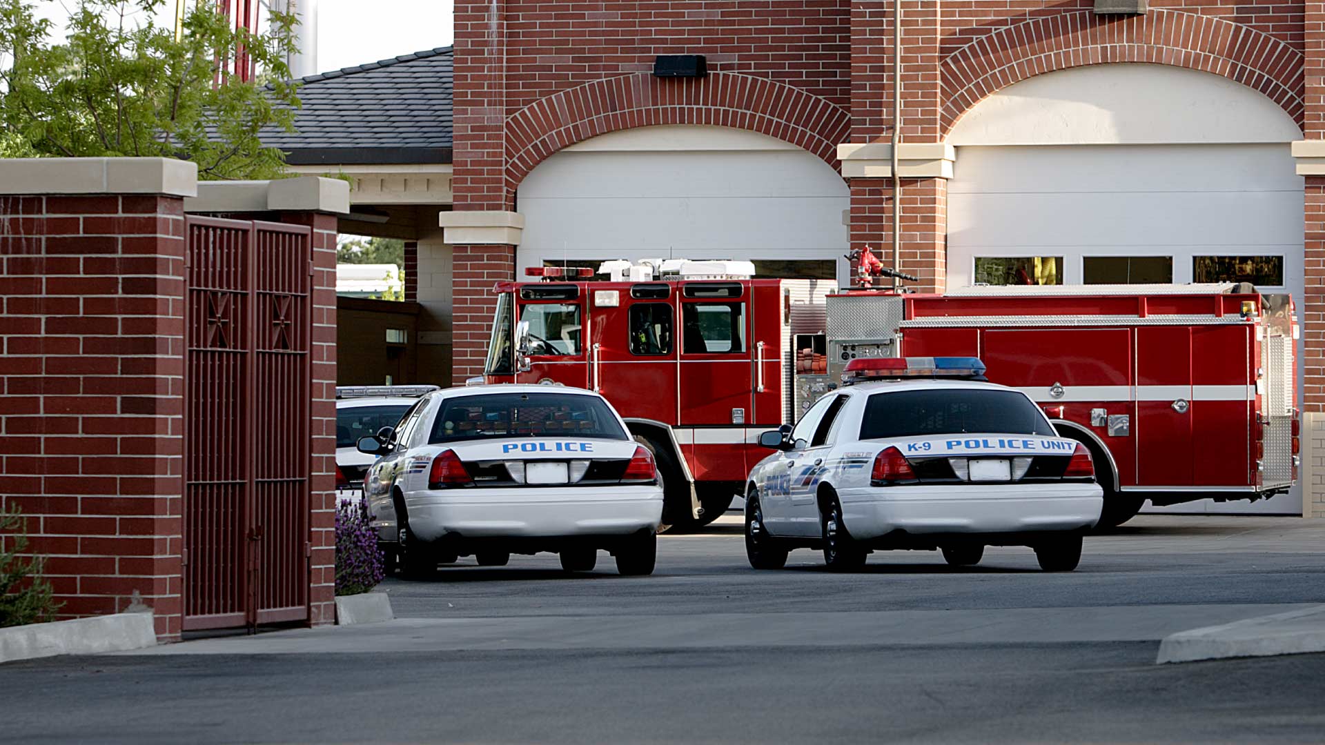
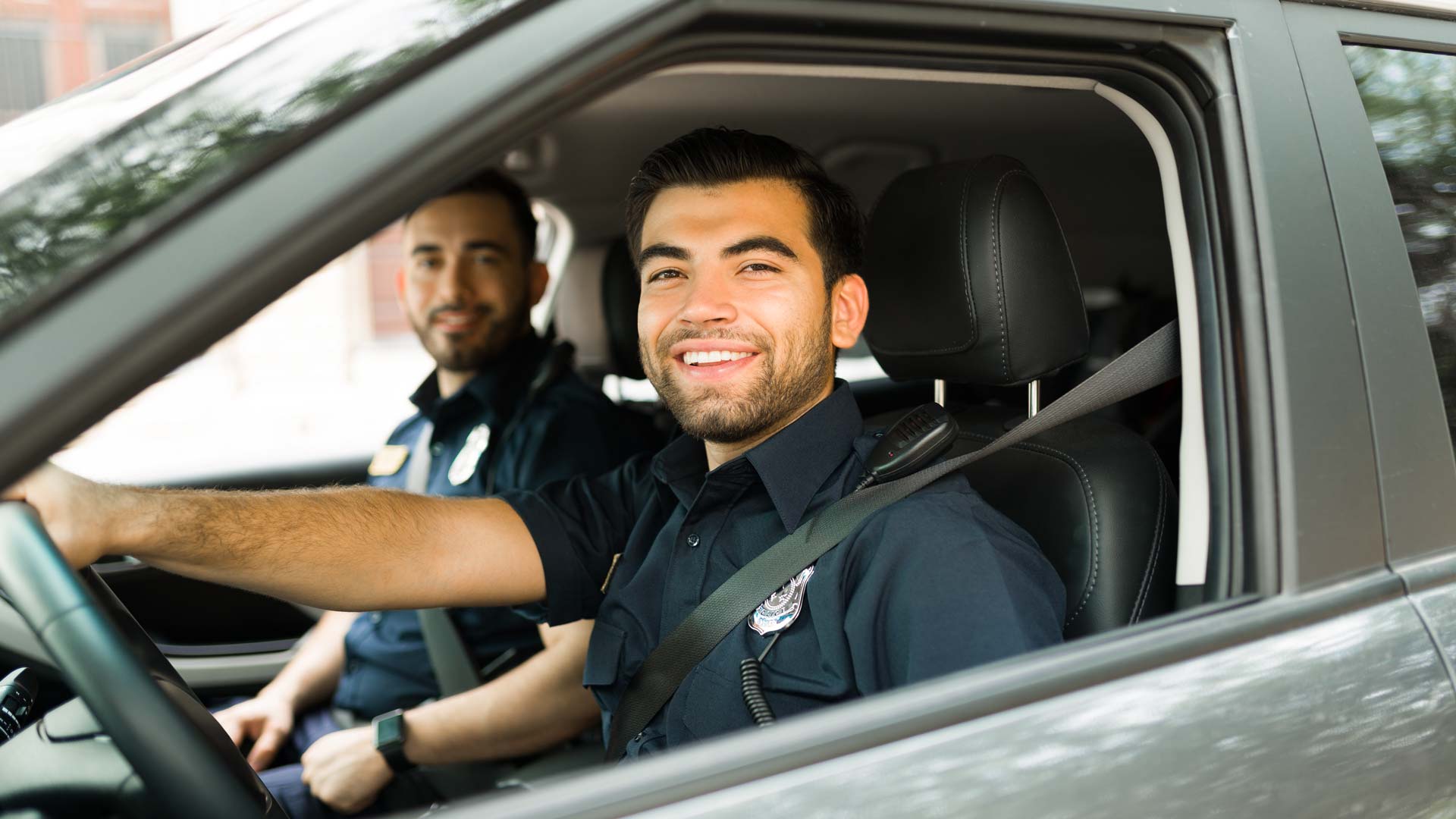
Many fleets are concerned with responding quickly, but for police, first responders, and emergency medical services (EMS), it affects lives. In addition to day-to-day challenges, many factors such as growing cities, increasing number of calls, or understaffing put extra pressure on fleets when trying to meet targets. In this article, we review some solutions that can help streamline operations for first responder fleet vehicle tracking.
Geotab offers many tools and features for fleets in law enforcement and emergency services.
- Active Tracking
- Dispatch Nearest
- Geotab Drive Messaging
- IOX-Garmin Telematics Hardware Add-On
- IOX-AUXM Telematics Hardware Add-On
1. Active Tracking
Having a clear picture of the location of vehicles is essential for fleet tracking. Active Tracking delivers location information with higher frequency and precision. This premium quality tracking solution is available to Geotab users allowing one to see your first responders driving in near real-time on the Map.
Learn More: Read how Active Tracking works and watch the video.
2. Dispatch Nearest
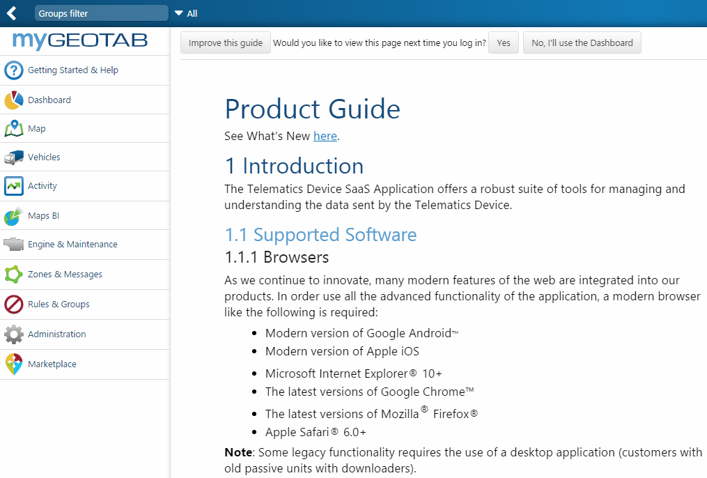
The Nearest feature in MyGeotab allows you to click on the map and quickly find the closest vehicles to the location selected.
How to Dispatch the Nearest Vehicle to an Emergency Address:
- Log in to MyGeotab and click on the Map. Click Select all to pick all vehicles from the drop down menu. This will now display the location of every vehicle in your fleet.
- In the search bar, type in the address of the emergency and click on it. This will be displayed on the Map.
- At the top of the page, click on the Nearest button — or you can right-click on the Map and click Nearest. This will now show you which of your vehicles is nearest to that location. On the address that is now pinned on the Map, right click and select Dispatch Vehicle Here.
- For the recipient, enter the name of that Nearest available vehicle and click Send. You can send this information to more than one vehicle, if necessary.
- The vehicle will now receive this address through the Geotab Drive/Garmin and can navigate to the location immediately.
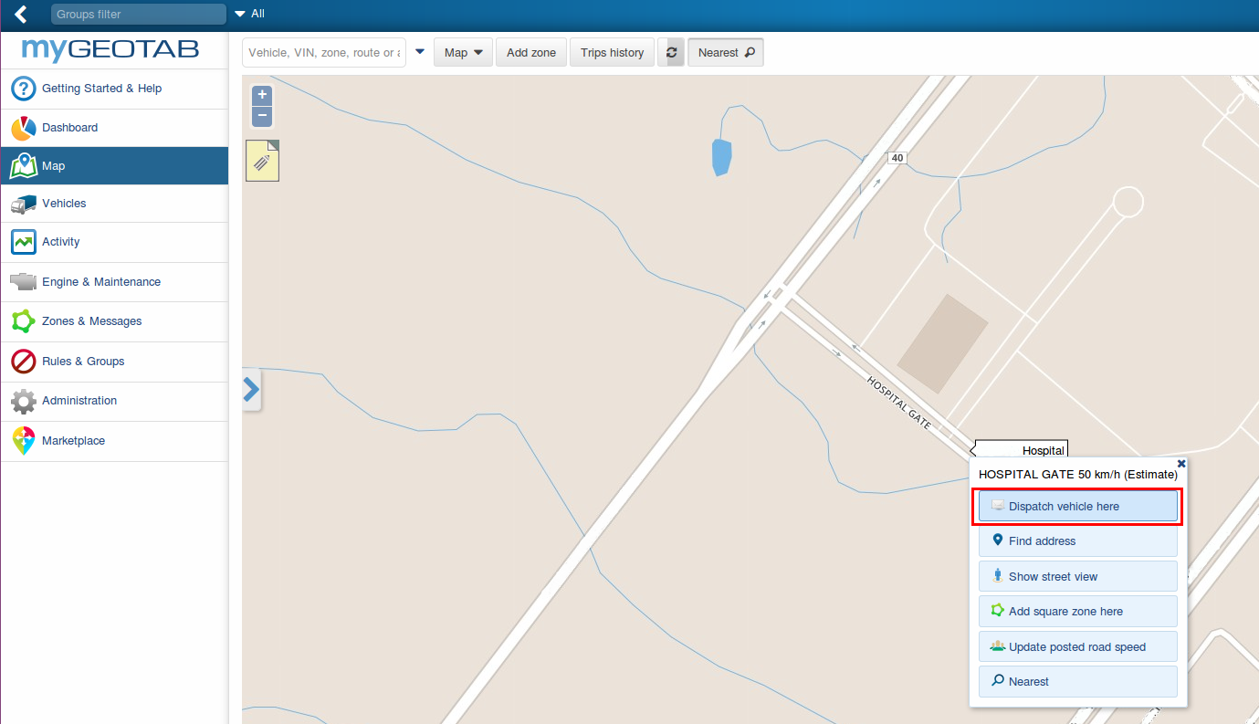
Dispatch nearest feature in MyGeotab
3. Geotab Drive Messaging
To keep emergency workers safe, first responder fleets must be able to stay in close communication. Messaging is now available in Geotab Drive. In order to use messaging, make sure Feature preview is enabled in your user profile and then your administrator can set up a clearance for messaging for you. To learn how to create a security clearance for users in MyGeotab, watch this video.
Creating Custom Messaging Clearance
From your MyGeotab database, from the main menu select User, and then click on Clearances at the top of your screen. In the search box, search “Drive App user” and select it. At the top of the page select Add Sub-Clearance.
- Search for “HOS” in the last search box on the page. Deselect Administer HOS Logs and View HOS Logs.
- Search for “DVIR” in the last search box on the page. Deselect Administer DVIR Logs, Mark DVIR logs as repaired and View DVIR Logs.
- Search for “messages” in the last search box on the page. You have the option of enabling “Delete messages” feature for your driver.
- Upon completion, name the sub-clearance level, “First Responder” and select Save.
Setting Up Drivers Before Logging In
From the main menu, select Administration > Users. If your driver is already within the database, search for their name or email in the search box above. To learn how to add users in MyGeotab, please watch this video.
Ensure that the driver has the security clearance set to First Responder in the User tab. Then select the UI tab, turn on Feature Preview for this driver. Select the Save button at the top of the screen.
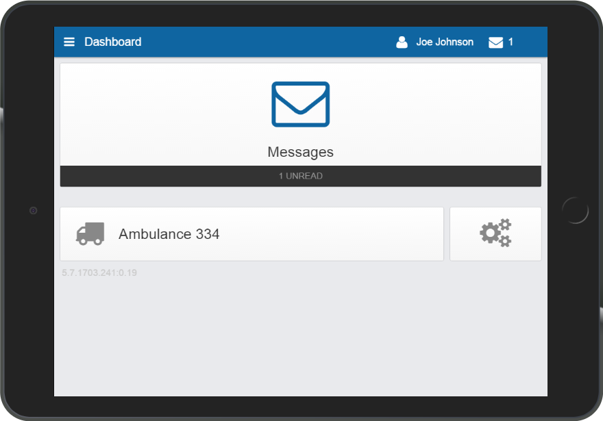
This is the Dashboard upon login for the driver with a First Responder security clearance in Geotab Drive.
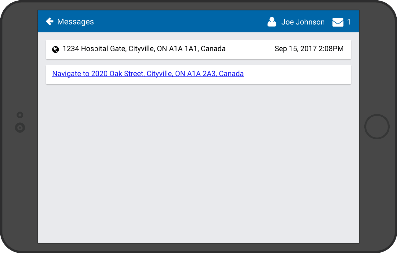
Sending Dispatch Location Via Geotab Drive
When you send the address of the emergency to the vehicle/driver, the driver will receive this in the Messages section of the App. The driver taps, then it will open the route in the navigation app of choice on their tablet or smartphone.
Note: The use of a navigation system requires cellular data on your mobile device to display the routes. Please use at your own discretion.
To review the steps for dispatching the Nearest Vehicle to an Emergency Address in Geotab Drive, jump to this section above.
The driver will receive the message as seen below. By simply clicking on the link, the route navigation through Google Maps will commence.
4. IOX-GARMIN
What if you could also know the availability of your first responders at all times? Equip your drivers with IOX-GARMIN to make dispatching easier. Set up status groups so that your drivers can keep you updated on their working status. For example, if a first responder is already taking on an emergency, they can set their status to “Emergency.” Each vehicle can have four available status options to choose from.
You can also send messages with the location of the emergency to Garmin.
1. To do this, go to MyGeotab > Rules & Groups > Groups. Under the Company Group, create a group called “Status Groups” with subgroups for each of the statuses below and Save.
- Available
- On-Call
- Emergency
- Not available
2. Under the Vehicle Edit page, click on the Groups tab and under Messaging Status Groups, select the status groups to add to the vehicle. Once these are saved, the driver’s Garmin will be updated and they will have these status options to choose from.
3. Drivers can set their status by choosing Quick Message. These statuses will be displayed when hovering over their location on the Live Map in MyGeotab.
4. From the Map, you can also select from the Map drop down menu > Highlight groups > Status Groups. By assigning colours to the Messaging Status Groups when you set them up, you will be able to differentiate the status of each of these vehicles by colours on the Map as well.
Geotab supports any Garmin model that supports FMI 15 or FMI 45 interface. Find more information in this IOX-GARMIN spec sheet.
5. IOX-AUX
What if you are a first responder and you have reached the emergency and realize you need more hands on deck? Set up an IOX-AUXM to a alert button in the vehicle. Then, create a rule in the system for this, so that every time the button is pressed one or more person can be notified immediately.
Adding an Exception Rule for Aux1
The Geotab Add-On IOX-AUXM can monitor four different signals from the vehicle in real-time (which doubles to eight signals with two IOX-AUXMs). It can measure events such a door opening and closing, seat belt sensors and sirens on emergency vehicles.
If you have the alert button wired to Aux 1 for example, you can create a rule in MyGeotab and set up recipients to be notified when this alert button is pressed (see steps below). You can also create a distribution list, which is a reusable list of multiple recipients.
- Navigate to MyGeotab > Rules & Groups > Rules > Add (top of the page).
- Enter the name of what you would like to call the rule and select which groups you would like this group to affect in your fleet.
- Under conditions, click More and select Aux 1 for example, (choose the Aux your input is connected to). Select True or False for when you want the rule to break and select Add.
- Under notifications, click Add email, select the email template of choice and enter the email address of the person that you would like to be notified when this occurs. You can also set up a distribution list so that more than one person receives this alert.
You can also connect IOX-AUXM to signals such as the emergency lights on an ambulance or police car and set up rules similar to above. You can use the data collected to measure your first response time and find ways to constantly improve your efficiency. These are just a few examples of how to expand with this Add-on to find out additional insight on your fleet. Find more details on Geotab’s IOX-AUXM here.
Contact your authorized reseller to purchase or find out more information about any of these features.
More Features for First Responders
Here is a summary of even more telematics features that apply to police and first responders.
Productivity
- Analyze gas mileage performance in detail.
- Compare fuel economy of different makes and models to make a well informed decision when vehicles require replacement.
- Analyze driving patterns to provide coaching to driver whose driving habits lead to poor fuel consumption.
- Monitor overall vehicle’s health ensuring minimal vehicle downtime due to failure.
- Alert when routine maintenance is required.
- Custom DVIR list.
- Alert when fault code is thrown allowing for medication remodification of the issue.
Safety
- Monitor unsafe driving that require coaching.
- Use of near instant driver feedback to immediately correct unsafe driving habits.
- Monitor the use of seatbelts ensure safety of first responder.
- Report superiors if an emergency vehicle has been involved in collision.
Expandability
- Monitor when siren is in use to to reduce noise pollution in residential areas.
- Monitor when lights are in Use to indicate how often first responders are called to a specific geographic area.
- IOX connectivity to collect a patient’s vital signs and wirelessly transmit them to emergency room doctors.
- IOX to monitor drug box usage.
- Temperature sensor to monitor environmental ideal patient conditions during transportation.
- Temperature sensor to monitor vital drug temperatures.
- Use of bluetooth beacons to ensure equipment is not left behind.
- Integration with Electronic Health Record systems.
Fleet Optimization
- Avoid high traffic areas.
- Dispatch nearest emergency service vehicle.
- Associate different drivers to vehicle’s trips for increased accountability.
- Send address to responding vehicles instantly.
If you want to learn how to optimize your first response time and efficiency with Geotab, please visit our fleet management solutions page.
Related:
Going Beyond GPS Tracking: Power Up With Fleet IoT and Hardware Integration
Subscribe to get industry tips and insights
Sabina Martin
Sabina Martin is the Vice President of Product Management at Geotab
Table of Contents
Subscribe to get industry tips and insights
Related posts
Embracing public safety technologies in the face of opposition
April 15, 2025
4 minute read

What is government fleet management software and how is it used?
April 10, 2025
3 minute read

Enhancing student bus safety: Combating distracted driving in the digital age
April 7, 2025
6 minute read
How a data driven policing environment elevates your department’s potential
March 24, 2025
4 minute read