The future of mapping and OpenStreetMap
Having a comprehensive map is important in the telematics industry as it serves as a tool that provides an easy to understand visualization of real-world data.
By Geotab
Dec 27, 2023

Having a comprehensive, up-to-date, map set is important in the telematics industry as it serves as a tool that provides an easy to understand visualization of real world data. There are many companies in the marketplace that provide good mapping solutions – however, they do not always offer the most affordable options. Because of this, it was only a matter of time before a free, open collaborative mapping project was unleashed. OpenStreetMap was born in August of 2004 and the number of contributing mappers has grown to over 1,601,160 as of April 2014.
How OpenStreetMap (OSM) Works
OpenStreetMap is an easy comparison to Wikipedia since anyone can make an account and start making changes. It is part of human nature to need things to be complete – when we notice a road is missing we feel the need to add it, or if your favorite hiking trail does not exist, just add it in. As the number of map contributors grow, OpenStreetMap will become the most up-to-date map set available. For example, below is a snapshot of the level of detail that the community of mappers has put into the downtown Toronto area.
A map isn’t just a picture anymore, it has evolved to a much more detailed tool.
A road has a lot more detail than where it starts and where it ends: it has a speed limit, paving type, road type, number of lanes, direction of traffic, and so on. These details are not always going to be the same, and in fact they are changing at an exponential rate. As new buildings are put up, stores and locations change, walking trails are cut, roads are built, and speed limits are changed, the map will need to be updated. At this rate how can a map provider keep its data up to date? The only answer is through open collaboration.
Geotab is one of the many companies that has invested in the OpenStreetMap project. Their recent donation has allowed the project to release a world wide address layer. This is big news to companies currently paying for this service from other providers. We at Geotab would like OpenStreetMap to be the best map set out there. This is why we, like other big companies, are giving back to the project in any way we can.

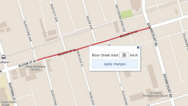
A new feature in Geotab’s web application, MyGeotab, allows administrators and supervisors to select and edit road speed data in real time. This data will “override” the speed data for that road, which will instantly be applied, and thus any vehicle driving down that road can be dinged for speeding at this new value. While allowing for complete flexibility, Geotab has a system that prevents this from being abused. Periodically these “overrides“ are donated to the OpenStreetMap community of mappers to use as a reference. They validate that the speed is valid and add it into the project, after these are all done Geotab will clear these “override” datas and use the newly verified OpenStreetMap data.
Speeding rules are becoming increasingly important to organizations, and with the continually improving posted road speed data on OpenStreetMap, we believe this is one step closer to perfection. We are going to continue to support the mapping community and we are looking forward to seeing this project continue to grow in the future.
Subscribe to get industry tips and insights
Geotab team
Table of Contents
Subscribe to get industry tips and insights
Related posts

Unified data: The key to fleet liability reduction for government agencies
March 19, 2026
9 minute read


Building a proactive government fleet safety program with data and AI
March 9, 2026
5 minute read
Telematics trends for 2026: What is changing and how fleets can respond
January 30, 2026
6 minute read
Fleet GPS tracking systems cost: Full price breakdown and ways to boost ROI
January 30, 2026
6 minute read