Traffic modeling for route optimization
Learn how a good traffic model improves route optimization, helping you choose the best route and keep deliveries on-time.

The best way to effectively plan delivery is to use a planning tool that does it for you. Such a tool must be flexible enough so that the delivery planner can include all of its delivery constraints such as truck capacity, multiple time windows, etc. In addition, the tool must be accurate enough so chances are increased that deliveries occur as planned and the best possible route is chosen. A good traffic model is crucial to ensuring the latter.
See also: Five ways a route planner can help improve your profitability
Route optimization: Plan deliveries better with traffic modeling
Most delivery and fleet routing software providers do not include any traffic model while calculating the traveling time between point A and B.
A few of them include a very simple traffic model where the traffic is only dependent on the time of the day, independent of where you are in the city. However, this proves to be insufficient as the traffic is heavily dependent on the time of the day, the day of the week, the location in the city and the direction of driving. If we take the example of Santiago de Chile, the traffic around the city center is very different at 8 a.m. compared to the traffic near the airport at the same time of the day.
It is therefore important for software companies developing delivery planning tools to develop models that allows for a far more accurate prediction of traffic.
A good traffic model should at least allow for a prediction of traffic in function of:
- the time of the day
- the day of the week
- the location within the city
- the direction of movement
This allows the delivery planning tool to accurately predict the time in traffic between any two points in the city and improves the quality of the optimized route.
See also: Optimize your telematics solution in six simple steps
Visualizing the traffic
Let’s visualize the prediction of our one such model. In the video below, we show the average increase in time it would take you to travel by car at a given time across the city. We use Santiago de Chile as an example but we can train a model for any city in the world. You realize right away that including this traffic in the planning process is crucial in obtaining a feasible plan that will allow you to deliver the best service to your clients.
The changing traffic in Santiago de Chile
If you play the above video, you will see the traffic evolving over time across the city — propagating in the morning from the residential areas towards the center of the city.
At lunch time, we see that the highest traffic is in the historic city center. Therefore, our planning tool can avoid this area around noon, if at all possible given the other constraints of the problem and the available number of trucks. Around the commercial areas and the historic city center, there is a huge peak in traffic starting around 6 p.m.
In the previous video, we did not show the direction of driving, although it is included in the model. However, this is a very important component as the traffic is very different when traveling towards the city center in the morning or away from it.
In the image below, we show how different the traffic is modeled when travelling towards the commercial area of the city of away from it around peak hour.
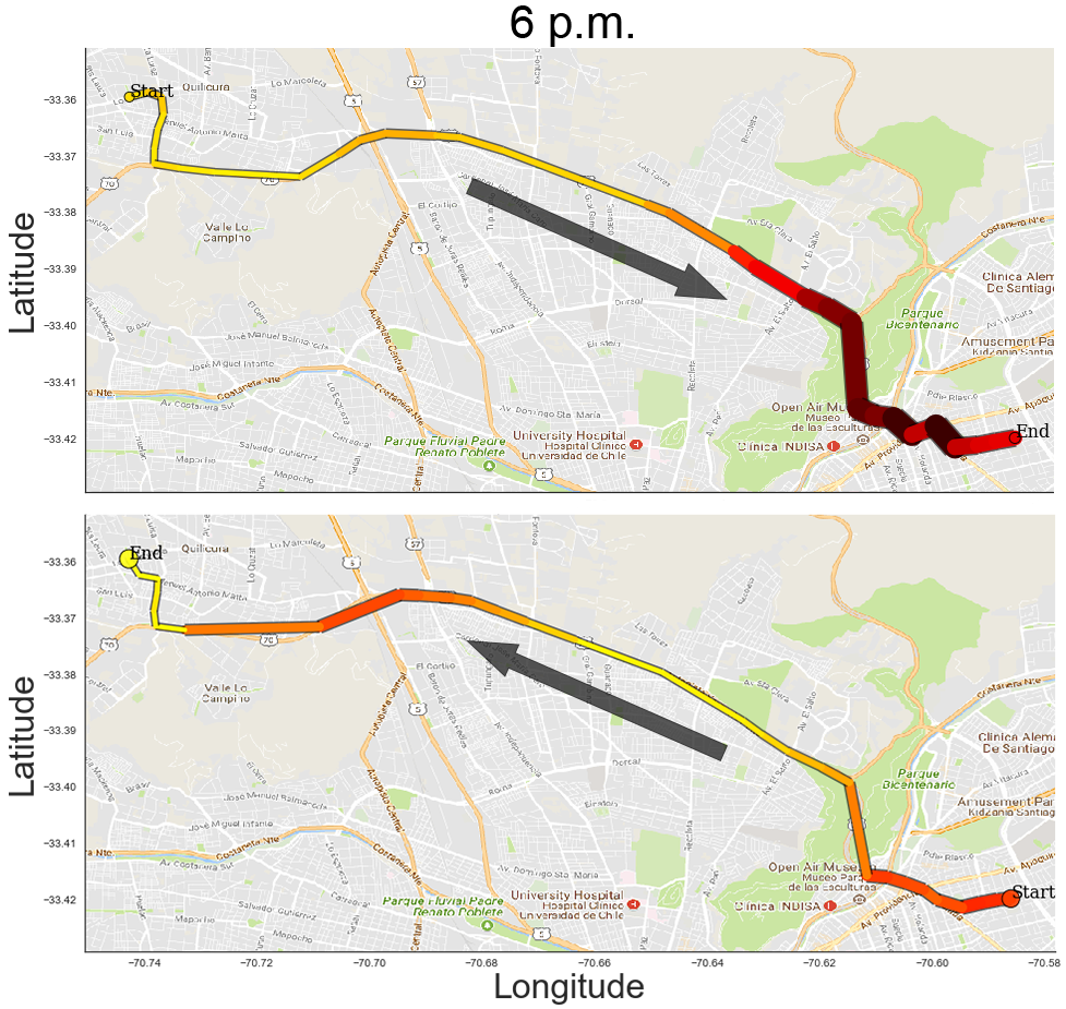
Comparison of Santiago de Chile traffic at 6 p.m. in two directions
Optimizing the delivery route with the traffic model
Few delivery planning software include such detailed traffic models in their algorithms. This is due to the fact that:
- it is difficult to model the traffic spatially and temporally, and
- standard approaches to solving the delivery route problem cannot use a traffic model as they require a static traveling time matrix between the points in the city.
Therefore, few providers are able to deliver an optimizer that takes into account the traffic information.
Although it’s impossible to exactly predict the traffic that will be present the next day. However, having an algorithm that allows this approach significantly improves the planning process as it accounts for variation in traveling time depending on the time of the day and the location.
In addition, this would be impossible to do this by hand, knowing all the traffic in the whole city at any time during the day. Therefore, this helps even more logistics planner to perform their job.
How to build a traffic model for route optimization
Without entering in too much details, let us briefly explain how a traffic model can be built. This model is built with a two-steps approach:
- Temporal model: We extract typical traffic pattern during the day. For example, one pattern could be a large traffic in the morning and little traffic in the afternoon. Another pattern could be an increase in traffic at midday. The traffic in an area is simply the weighted sum of each component.
- Spatial model: The weights that activate each temporal component is different in each part of the city. Using cutting-edge statistical methods, we can predict how much each component is activated for each point in the city. This model uses four dimensions: latitude, longitude, and the direction vector.
This two-step approach allows to understand relevant traffic patterns and to efficiently calculate the traffic at any time during the day, anywhere in the city. It is very important that this calculation is very fast and robust so that it can be included in the optimization process which requires the computation of traffic for hundreds of thousands of trips at various times during the day.
If you would like more details on how a traffic model can be built and integrated within an optimization software, please go to Drivin Smart Deliveries on the Geotab Marketplace and click Request Info.
About Driv.In
Drivin helps logistic companies face their most complex challenges when distributing in urban areas: customers expectations are difficult to handle, cities are very congested and transportation costs are on the rise. Drivin provides an easy-to-use service to tackle these challenges that optimally plans delivery routes, provides a proactive real-time monitoring and collects relevant indicators that help to improve the level of service that our clients offer to their customers.
Subscribe to get industry tips and insights
The Geotab Team write about company news.
Table of Contents
Subscribe to get industry tips and insights
Related posts

What is government fleet management software and how is it used?
April 10, 2025
3 minute read


How to avoid high downtime costs for construction fleets
March 10, 2025
2 minute read

Geotab Data Connector gets an upgrade for better fleet insights
February 24, 2025
1 minute read
Driver incentive programs to improve safety, retention and fleet efficiency
February 7, 2025
4 minute read