America’s historic ghost towns, mapped
Published on October 17, 2018
Interactive map reveals the beauty of 10 historic ghost towns in the U.S
- The states with the most ghost towns are Texas (511), California (346) and Kansas (308), while Rhode Island (1) and Connecticut (4) have the least
- The counties with the most ghost towns are Kern County, California (113), Lawrence County, South Dakota (93) and Indiana County, Pennsylvania (36)
Toronto, ON - October 17, 2018 - Geotab, a global leader in IoT and connected transportation, today revealed an interactive map showcasing historic ghost towns across the United States. Gathering data from over 3,000 abandoned towns across the country, the piece showcases the number of ghost towns in each U.S. State and highlights 10 striking examples of these historic communities.
“In many parts of the world, people may wander around ancient ruins, but they rarely encounter a true ghost town, stated Peter Ling, Professor of American Studies at the University of Nottingham. “In contrast, Americans know them as vivid reminders of the country’s compressed, dynamic and turbulent past: places that once thrived because of rich natural resources, viable transportation links, and booming populations, but then faded away.”
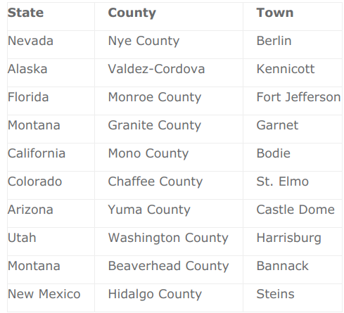
Geotab’s “Ghost Towns of America” map series allows users to explore the cities with the most neighboring ghost towns within a 25 to a 50-mile radius or by location and distribution across America’s states and counties. Focusing on history and the structural remains left, the piece spotlights 10 compelling examples of American ghost towns by diving deeper into their story and showcasing a selection of high-res photos that allows users to explore what these towns look like today.
The 10 ghost towns featured by Geotab are:
“These ghost towns are places that Hollywood has seeded in our heads, where outlaws ride into town while miners gamble away newly acquired fortunes,” added Ling. “A trip out west is rarely complete without a visit to a ghost town, giving those places a second chance to thrive; heritage tourism can be a mother lode they continue to mine indefinitely.”
The states with the highest number of ghost towns are Texas (511), California (346) and Kansas (308). On the other hand, Rhode Island and Connecticut are home to the fewest, with just one and four respectively. Additionally, the counties with the most ghost towns are Kern County in California (113), Lawrence County in South Dakota (93) and Indiana County in Pennsylvania (36).
“The story of America is one of change. Many towns were built thanks to the growth of infrastructure, trade, and transport in the U.S., but those that have been abandoned leave behind a rich history. America’s ghost towns continue to serve as a useful reminder that the past can teach us a lot about the present.” said Maria Sotra, VP of Marketing at Geotab.
Explore the interactive map of ghost towns in full here and a press pack of imagery can be accessed here.
Methodology
To create the interactive map, Geotab collected lists of ghost towns in each U.S. state using a range of books and websites including ghosttowns.com and roadsidethoughts.com (full sources list), then identified the location of each (to a minimum precision of county level). Geotab then picked 10 historic ghost towns based on the nature of the story behind them and their abandonment, structural remains left on the site and the quality of photography available (factual sources; photo credits).
About Peter Ling
Peter Ling is Professor of American Studies in the Department of American & Canadian Studies. He is an author and regular contributor to BBC History and other magazines. Currently, he is working on the different ways American heritage is presented to both domestic and international audiences.
Post Tags
Media Contact
Nicole Riddle
Senior Specialist, Strategic Communications
pr@geotab.com
About Geotab
Geotab is a global leader in connected vehicle and asset solutions, empowering fleet efficiency and management. We leverage advanced data analytics and AI to transform fleet performance, safety, and sustainability, reducing cost and driving efficiency. Backed by top data scientists and engineers, we serve over 55,000 global customers, processing 80 billion data points daily from more than 4.7 million vehicle subscriptions. Geotab is trusted by Fortune 500 organizations, mid-sized fleets, and the largest public sector fleets in the world, including the US Federal Government. Committed to data security and privacy, we hold FIPS 140-3 and FedRAMP authorizations. Our open platform, ecosystem of outstanding partners, and Marketplace deliver hundreds of fleet-ready third-party solutions. This year, we're celebrating 25 years of innovation. Learn more at www.geotab.com and follow us on LinkedIn or visit Geotab News and Views.
Related posts

Geotab and General Motors to Provide Connected Vehicle Offering for Government Fleets in U.S.
May 24, 2022

Geotab Launches Citizen Insights Solution for Government Agencies
October 19, 2021
.jpg)
Geotab selected as sole telematics provider for the State of Oklahoma
September 21, 2021
Recent News

Puerto Rico Government Selects Geotab for Telematics Solutions
April 17, 2025


Geotab Wins a Google Cloud Partner of the Year Award
April 8, 2025