Geotab’s telematics technology now on all seven continents
Published on April 24, 2018
British Antarctic Survey selects Geotab telematics to increase safety of researchers on Antarctic ice shelves
London, UK – April 24, 2018 – Geotab today announced that it is the first leading global telematics provider to be present in all seven continents. Selected by the British Antarctic Survey (BAS) to support its diverse fleet of vehicles in Antarctica, Geotab’s telematics solution will be used to automatically report location and to help improve driver safety.
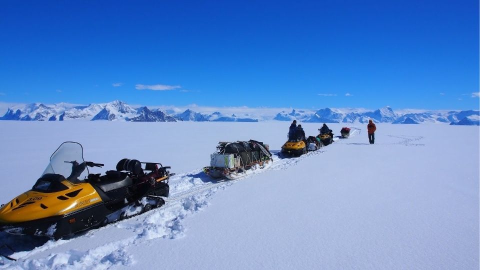
BAS researchers track changes in critical Antarctic glaciers in order to better understand future sea level rise. An essential part of the research logistics is the large fleet of vehicles, including snowmobiles, which BAS relies on to help carry out scientific programmes across the harsh and constantly changing conditions of the Antarctic. To ensure the fleet remains reliable and succeeds in supporting vital environmental research operations in temperatures that can drop to minus forty degrees celsius, Geotab GO devices have been deployed across a number of BAS vehicles.
“Our vehicles undergo extensive preparation to ensure optimal performance and efficiency before being deployed to Antarctica and we always take extra care to ensure our research specialists are equipped with the training and tools necessary to succeed,” said Timothy Gee, Tractor Traverse Engineer at the British Antarctic Survey. “Despite this however, when vehicles are exploring the ice shelves, they are in a very hostile environment and conditions can change very quickly. Using cutting edge telematics technology on our vehicles allows us to not only know where our vehicles are, but gives us peace of mind that our researchers are safe.”
Equipping a number of BAS snowmobiles with Geotab GO devices, the vehicles will automatically send location information and will include a Geotab IOX to act as a ‘panic-button’ to help ensure driver and operator safety. By enabling drivers to alert local and UK-based management to serious problems, the panic button can help prevent minor accidents from escalating into life-threatening incidents – a critical safety factor given the harsh terrain in Antarctica.
“Geotab is honoured to be providing mission-critical telematics coverage in support of the British Antarctic Survey’s scientific exploration of the Thwaites Glacier,” said Neil Cawse, CEO, Geotab. “As we continue to support over one million connected vehicles, now across all seven continents, Geotab’s commitment to safety, optimisation and doing our part to build a greener economy will only grow stronger.
“The BAS’s vital research aims to substantially improve our understanding of future global sea-level rise. Being able to help keep the BAS team and its fleet safe and operational, is a top priority for a globally important expedition,” adds Cawse.
About British Antarctic Survey
British Antarctic Survey (BAS), an institute of the Natural Environment Research Council (NERC), delivers and enables world-leading interdisciplinary research in the Polar Regions. Its skilled science and support staff based in Cambridge, Antarctica and the Arctic, work together to deliver research that uses the Polar Regions to advance our understanding of Earth as a sustainable planet. Through its extensive logistic capability and know-how BAS facilitates access for the British and international science community to the UK polar research operation. Numerous national and international collaborations, combined with an excellent infrastructure help sustain a world leading position for the UK in Antarctic affairs. For more information visit www.bas.ac.uk.
Post Tags
Media Contact
Nicole Riddle
Senior Specialist, Strategic Communications
pr@geotab.com
About Geotab
Geotab is a global leader in connected vehicle and asset solutions, empowering fleet efficiency and management. We leverage advanced data analytics and AI to transform fleet performance, safety, and sustainability, reducing cost and driving efficiency. Backed by top data scientists and engineers, we serve over 55,000 global customers, processing 80 billion data points daily from more than 4.7 million vehicle subscriptions. Geotab is trusted by Fortune 500 organizations, mid-sized fleets, and the largest public sector fleets in the world, including the US Federal Government. Committed to data security and privacy, we hold FIPS 140-3 and FedRAMP authorizations. Our open platform, ecosystem of outstanding partners, and Marketplace deliver hundreds of fleet-ready third-party solutions. This year, we're celebrating 25 years of innovation. Learn more at www.geotab.com and follow us on LinkedIn or visit Geotab News and Views.
Related posts

Santa’s Sleigh Runs on Magic – But It’s Telematics That Keep It Efficient and Sustainable
December 18, 2024

Geotab’s 2025 Predictions: AI Powers Efficient, Safer Fleets
December 12, 2024
.jpg)
Empowering fleets through data: Geotab and Rivian partner to deliver integrated telematics solution
May 21, 2024
Recent News

Geotab Wins a Google Cloud Partner of the Year Award
April 8, 2025

Not an April Fools’... telematics firm Geotab helping British scientists take a comfier poo in the Antarctic
April 1, 2025

Revvo Joins Geotab’s Order Now Program to Deliver AI-Powered Tire Intelligence, Reducing Downtime & Maximizing Fleet Efficiency
March 27, 2025
